

[This is part of BFNow Self-Study Module 2: Objects, Categories, Territories & Maps. For more about the overall Self-Study program, please look at About BFNow Self-Study and BFNow Self-Study Orientation.]
If you haven’t done so already, let me encourage you to pause, relax and release, perhaps with a big stretch or three deep breaths.
This post provides an introduction and overview to territories-and-maps as a way of perceiving. It builds on the material in System Literacy Part 1, starting at 12:34 and going to 16:19. The following two Exploration Posts will get into applications and how we can use these tools.
The terms we’ve used so far – objects, categories, concepts – are all part of the standard psychological vocabulary. Territories & maps belong more to the language of systems but I’m going to approach them from an hOS perspective. Don’t expect to find this material in the regular psychological literature (yet 😉).
Object perception and categorical thinking are prime examples of thinking-fast as described in Daniel Kahneman’s book and hOS Literacy Part 2. As I’ve been describing, they work fabulously in some situations but are overly simplistic and error prone in others.
I think of territories-and-maps as a thinking-slow counterpart to object perception and categorization, a companion that integrates well with systems thinking, which is a thinking-slow counterpart to categorical thinking.
By the way, the word “system” turns out to be a problematic in practice because it’s commonly used to refer both to “things out there” (territories) – as in the Solar System – and to “human constructs” (maps and models) – as in a Market System model of economics. Yet the map is not the territory so we use “territories” and “maps” rather than “systems” to keep “what’s out there” easily separated from the human constructs.
Example
To ground this in something concrete, I’d like to start with what I think of as an archetypal example of territories & maps, namely Geographic Information Systems (GIS).
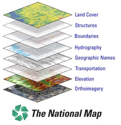
Each layer here is a separate map with its own data and purpose yet they all refer to the same territory. Each map contributes to the description of the territory but even all of them together don’t provide a complete description.
This geographic example provides the base metaphor for the more general idea of territory (what is being described) and map (a partial description of the territory). In its more generally use, the territory does not need to be geographic or even physical. Ideas – like morality, justice, religion, and freedom – can also be approached as territories, illuminated by multiple maps.
Theory and Terms
Now let’s generalize beyond that example. As an approach to perceiving, territories-and-maps proceeds by
separating delineation (of the territory) and description (via the map) – This allows multiple maps to be associated with the same territory, which in turn allows the map you use to be responsive to context and the specifics of the moment. Research and study of all kinds have always involved this kind of separation between 1) the delineation of the subject area and 2) the results of specific investigations. What’s different here is applying this separation throughout everyday life.
treating each map as partial, selective and provisional – We expect that, in general, the potential of what could be described about a territory, if we attempted a complete description, is enormous. (You will get a taste of this is today’s experiential.) To be useful, each map describes only part of that potential (partial) and we select what to describe (selective) based on our purpose for having the map. Since each map is partial and selective, there is always more that could be learned and ways the map could be modified (thus the map is provisional). The map is an interface between the territory and the observer, and depends on both. As in quantum physics, the observer matters. There is also no such thing as the one true map – in a timeless, context-free sense – only maps that are good enough for the present purpose.
using the where pathway and the what pathway equally – Just as language repurposed the what pathway to enable abstract categories via word-objects, so territories-and-maps repurposes the where pathway to enable “visualizing” abstract system relationships via diagrams and other visual representations. Those visual representations can be dynamic as well (as in system models and animations). Maps generally can be described as systems and, as I said in Systems Literacy Part 1, starting at 16:19, systems are an interface made up of diagrams (where pathway), descriptions (what pathway) and dynamics (where pathway).
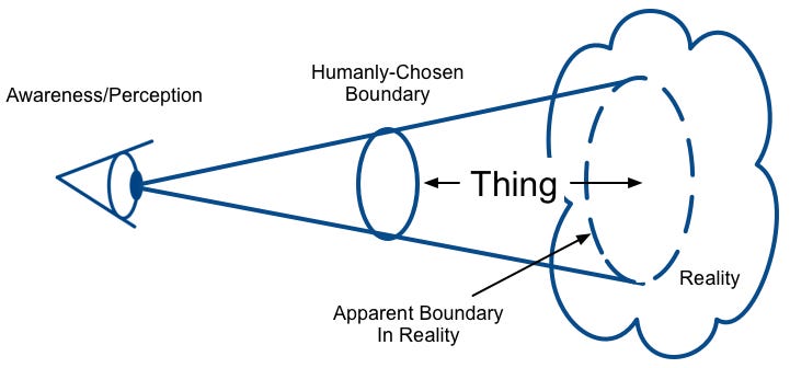
With that as framework, let’s look more deeply at the process of perception from the perspective of territories-and-maps. To do so, we’re going to need a way to talk about what’s “out there.” Since object doesn’t serve that purpose, I suggest we continue to commandeer thing.
Let’s define a thing as a part or aspect of Reality. Since Reality doesn’t have its own internal boundaries, a thing needs to be a hybrid of
a humanly-chosen boundary or criteria for what part of Reality to look at; it delineates the territory
the parts of Reality within that boundary or matching those criteria.
Schematically, it looks like this:
It is important to understand that the same thing can be approached as an object, as an instance of a category or as a territory. Object, instance or territory isn’t a property attached to the thing, rather each is a choice we make about how to relate to the thing.
The idea that it’s a choice matches what we know about the Human Operating System but it’s not what most people assume. For example, even people steeped in systems thinking assume that being a “system” is an objective property of something “out there” and they argue of over what things are or aren’t systems. So let me repeat this distinction because it is so central to reframing how we relate to the world around us:
Object, instance or territory isn’t a property attached to the thing, rather each is a choice we make about how to relate to the thing.
In an Empire Era mind-set and even in a contemporary mind-set there is minimal awareness of this choice and only in limited situations are things seen as territories rather than objects or instances of categories. In the Planetary Era, I expect we will be well aware of this choice and we will move easily and fluidly between object/instance and territory/map depending on the situation.
If I choose to approach a thing as an object, then my subconscious, through the what pathway, will provide me with a perceived unit joined with a variety of associations (a mind-bundle), as I described in the “Objects” post earlier this module. Speed of identification and clarity of behavior scenarios are of prime importance.
If I choose to approach a thing as a territory, I’m taking a systems perspective. I begin by delineating the “boundary” of the territory. I also start with an initial detachment that is intentionally slow to make assumptions. I then look – in a conscious, thinking-slow way – at (some of) what’s inside the boundary so that I can make a map of the parts and relationships I find there.
In this process, I’m making use of the Parietal Lobe’s where pathway, which combines visual and kinesthetic inputs to create the experience of 3-D space, enabling broad spatial awareness. Even with non-physical territories, I use the where pathway to simultaneously hold onto the parts, the relationships, the boundary and the context that are the basis for my maps.
As a mind-bundle, a territory by itself (without its maps) mostly just says, “look here.” In this narrow sense, it is the mind-part of the thing, providing the boundary, the delineation. Yet it is more than that because of it’s associated maps; indeed it can be associated with an unlimited variety of maps. I think of the mind-bundle of a territory like this:
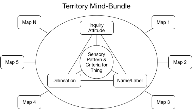
By explicitly separating the maps from the territory – the descriptions from the delineation – this approach escapes the “one size must fit all” limitation that plagues the object and category approaches. It increases complexity yet allows better adaptability.
Many of the associations (emotional, event, behavioral) that are part of an object mind-bundle are missing from a territory mind-bundle because they are attached to the maps instead. This helps my relationship to the territory to be more curious, open and non-attached.
Each map in turn can be a system with parts, relationships, a boundary, a context and the possibility of nested maps within maps. Think of a geographic map with symbols for cities, towns, roads of various kinds and other points of interest. There may even be inset city maps nested in the larger map.
Each part of this system (e.g. each city, road, etc.) will have its object-like mind-bundle. Overall, the mind-bundle for the map as a whole will look like this:
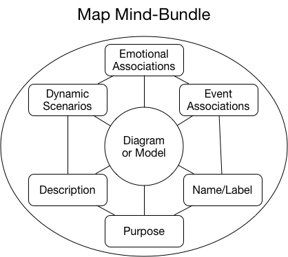
Each map has its own purpose. Some may be oriented towards speed of identification and clarity of behavior scenarios just like an object while others go for depth of understanding.
The territory-and-map approach is very flexible. At one end of the spectrum, it allows for a huge amount of information and associations to be connected to a territory via all of its maps. At the other, you can choose a simple map that may be all you need in your specific situation. Developing the maps takes some time and effort (thinking-slow) but with this approach it is possible to avoid the problems with object perception and categorical thinking that I described in the previous two days.
Experiential
Today’s experiential opens the door to experiencing a bit of the deeper story that can emerge when we approach the mundane things around us as territories.
(Don’t do this while driving or operating heavy machinery.)
Find something you can hold in your hand that comes from a plant source, like an apple, a book or something about that size. Edible is good but not necessary. The more familiar and taken-for-granted, the better.
Spend a minute or so examining it visually from all angles. Note all of its individuality. Take a comparable amount of time to feel it with your touch. Smell it. Make sounds with it. If it’s edible, don’t eat it, yet.
Spend another minute just “being with” it, sensing it intuitively. As you do this, you may get some images or feelings that seem to connect to this thing and/or its history. Whatever comes to you, including nothing, is fine.
Once you’ve had a rich multi-sensory and intuitive sensing experience of it, hold it or at least keep it in view while you consider the following:
The thing you are holding is likely connected to all past life. There are so many atoms in your thing (roughly 1024 within an order of magnitude or so) that chances are very good that some of those atoms were previously part of every human that ever lived and every animal or plant as big as your thing. The connection is weaker over the past few hundred years because it takes time for the recycling and mixing of gases to spread around the globe. Don’t worry about that detail. Just feel yourself holding a connection to hundreds of millions of years-worth of huge numbers of past living individuals of many species.
We can go even further. All of the hydrogen in your thing, in water or hydrocarbons, is 3 times older than the Earth, all the way back to the Big Bang. The other atoms were all birthed in massive stars in our galaxy. We are just starting to learn about quantum entanglement – where two particles can affect each other instantaneously over vast distances. It is possible that many of the atoms in your thing were entangled at birth. The carbon and oxygen may be entangled with their siblings in some other part of the galaxy. The hydrogen may be entangled with its siblings on the far side of the Universe. Tune into holding all of these connections in this familiar thing.
Look around your room and realize that everything else you see carries this depth of history and connection.
If your thing is edible, take a bite being conscious of now adding all of those connections to your own body.
How was this experience for you? Add some notes to your journal and do a version of this experiential twice more today.
Find opportunities throughout your day to consciously choose to approach various things as territories. Practice using the language of ‘territories’ and ‘maps’ at least to yourself. If you are in conversation with someone who is taking or has taken the course, practice using the language of ‘territories’ and ‘maps’ with each other.
If you have questions or comments, please post them here.
Thanks,
Robert
[Link back to the Module 2: Objects, Categories, Territories & Maps Overview page.]